Work Package Infrastructure
Route Overview

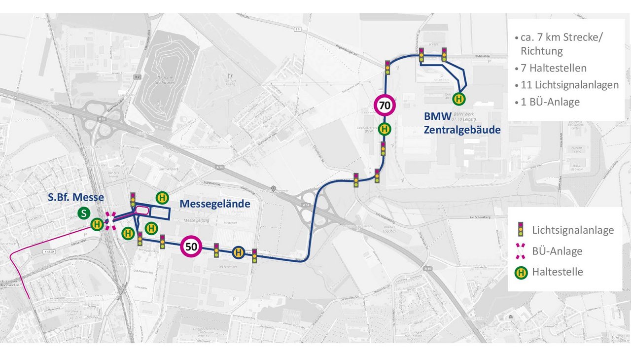
Darstellung der Streckenübersicht im Testfeld ABSOLUT
Minimalism in Infrastructure Upgrading
In contrast to other research projects, the ABSOLUT project is constantly exploring the boundaries between the sufficient and necessary infrastructure measures for automated driving. Since both a cross-area over-planning of roads, junctions, etc. as well as the area-wide use of the most diverse sensor and communication technologies do not seem feasible in the near future.
Of central importance with regard to the transfer to the tram and city railway is the trade fair area, which is structurally reminiscent of a shared space, which in its original planning was not designed for road-based public transport in regular operation. Missing markings, unsignalised intersections, GNSS shadowing and heavy pedestrian traffic represent the greatest challenges for an automated vehicle, which can currently only be met by reducing the vehicle speed and additional reference markers to support the positioning functions.
Bidirectional C2X Communication
The vehicle receives the following protocols standardised according to ETSI from a roadside unit on the respective control unit of the traffic signal system:
- SPaTEM (Signal, Phase and Timing Extended Message).
- MAPEM (Map Extended Message).
This ensures that the vehicle always receives information on the position of the relevant signalling device, its current signal status and the duration of the signal phase.
Furthermore, the vehicle sends out the protocol CAM (Cooperative Awareness Messages), which is also standardised according to ETSI, or CAM-R09 for public transport vehicles. With the help of this message, the vehicle is registered and deregistered at the traffic light system.
Quality Optimized Traffic Light Control
The once applied first-in-first-out principle has been outdated for years. In the meantime, an overall consideration of the traffic situation at the intersection is up-to-date. Accordingly, the needs of the individual traffic flows are determined and weighed up against each other for quality-oriented public transport priority. A decision-making system maps the logic of the respective intersection and selects the optimal public transport priority based on the knowledge of the public transport operating situation, the private transport traffic situation and the current status of the traffic light control system.
This type of public transport priority has already been used for several years in the state capital Dresden and in the city of Leipzig at more than 20 junctions, see the projects “Chamäleon” and “Stadtring”, and is currently planned for a large number of other junctions.
In the ABSOLUT project, quality-based public transport priority is also applied. Due to the automation, the precise vehicle position is known in real time, which means that a minimal and correspondingly more effective intervention in the LSA control or in the coordination along the route can be made.
Digital Map
To support precise location and better planning of driving manoeuvres, the automation systems in the vehicles need digital map material of the test track. This is a highly accurate 3D model of the infrastructure that is enriched with additional data content. For example, all traffic signs are stored with their content and assigned to the respective road sections.
OpenDRIVE was chosen as the starting format for the digital map material because of its application and distribution in the field of driver assistance systems and its possible integration into various development environments and simulation tools. This format makes it possible to describe and link elements of road networks in an XML-based manner.